Welcome to our site |
|||||||||||||||||||||||||||||||||||||||||||||||||||||||||||||||||||||||||||||||||||||||||||||||||||||||||||||||||||||||||||
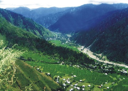
RED KASHMIR .jpg)   History of Azad kashmir

After the Partition of India in 1947, the princely states were given the option of joining either India or Pakistan. However, Hari Singh, the maharaja of Jammu and Kashmir, wanted Jammu and Kashmir to remain independent. In order to buy some time, he signed a stand-still agreement, which sidestepped the agreement that each princely state would join either India or Pakistan.[2] Later there was a revolution by Muslims in the western part of the kingdom[3] and the raiders from North-West Frontier Province and the Tribal Areas feared that Hari Singh might join the Indian Union. In October 1947, supported by the Pakistani Army, they attacked Kashmir and tried to take over control of Kashmir. Initially Hari Singh tried to resist their progress but failed. Hari Singh then requested the Indian Union to help. India responded that it could not help unless Kashmir joined India. So on 26 October 1947, Kashmir accession papers were signed and Indian troops were airlifted to Srinagar. Fighting ensued between the Indian Army and Pakistani Army, with control stabilizing more or less around what is now the "Line of Control".[4] Later, India approached the United Nations to solve the dispute and resolutions were passed to hold a plebiscite with regard to Kashmir's future. However, this plebiscite has not been held on either side, since the legal requirement for the holding of a plebiscite was the withdrawal of the Indian and Pakistani armies from the parts of Kashmir that were under their respective control—a withdrawal that never did take place.[5] In 1949, a cease-fire line separating the Indian- and Pakistani-controlled parts of Kashmir was formally put into effect. Following the 1949 cease-fire agreement, the government of Pakistan divided the northern and western parts of Kashmir which it held into the following two separately-controlled political entities:
An area of Kashmir that was once under Pakistani control is the Shaksgam tract—a small region along the northeastern border of the Northern Areas that was provisionally ceded by Pakistan to the People's Republic of China in 1963 and which now forms part of China's Uygur Autonomous Region of Xinjiang. In 1972, the then-current border between Pakistan and India, which held areas of Kashmir, was designated as the "Line of Control". The Line of Control has remained unchanged[7] since the 1972 Simla Agreement, which bound the two countries "to settle their differences by peaceful means through bilateral negotiations." Some political experts claim that, in view of that pact, the only solution to the issue is mutual negotiation between the two countries without involving a third party, such as the United Nations. A devastating earthquake hit Azad Kashmir in 2005. Azad Kashmir DayAzad Kashmir Day celebrates the 61st day of the Azad Jammu Kashmir government, created on 24 October 1947. Government
Azad Jammu and Kashmir (AJK) is a self-governing state under Pakistani control but is not constitutionally part of Pakistan.[1][8] It has its own elected president, prime minister, legislature, high court, and official flag. The government of Pakistan has not yet allowed the state to issue its own postage stamps, however, and Pakistani stamps are used in the state instead. Azad Kashmir has it own Judiciary as well with Khawaja Shahad Ahmad as its present Chief Justice. Azad Kashmir's financial matters, i.e., budget and tax affairs, are dealt with by the Azad Jammu and Kashmir Council, rather than by Pakistan's Central Board of Revenue. The Azad Jammu and Kashmir Council is a supreme body consisting of 11 members, six from the government of Azad Jammu and Kashmir and five from the government of Pakistan. Its chairman/chief executive is the president of Pakistan. Other members of the council are the president and the prime minister of Azad Kashmir and a few other AJK ministers.[1][8] The state is administratively divided into three divisions which, in turn, are divided into ten districts.[9]
A 2008 report by the United Nations High Commissioner for Refugees determined that Pakistan-administered Kashmir was 'not free', while Indian Kashmir was.[12] And a 2010 report by Freedom House confirmed that Pakistan-administered Kashmir was 'not free', while Indian Kashmir was 'partially free'.[13] There are roughly 1.5 million refugees from Indian Administered Kashmir in Azad Kashmir and Pakistan. Azad KashmirFrom Wikipedia, the free encyclopedia
This article is about the area administered by Pakistan. For other uses, see Kashmir.
    |
SYED MUDASAR BUKHARI  |
||||||||||||||||||||||||||||||||||||||||||||||||||||||||||||||||||||||||||||||||||||||||||||||||||||||||||||||||||||||||||


